
Southern California Braces for Impact as Hurricane Hilary Transforms into a Tropical Storm

As Hurricane Hilary undergoes a weakening transformation into a tropical storm, the arid deserts and lofty mountains of Southern California and southern Nevada are poised to endure the brunt of heavy rainfall and potential flooding.
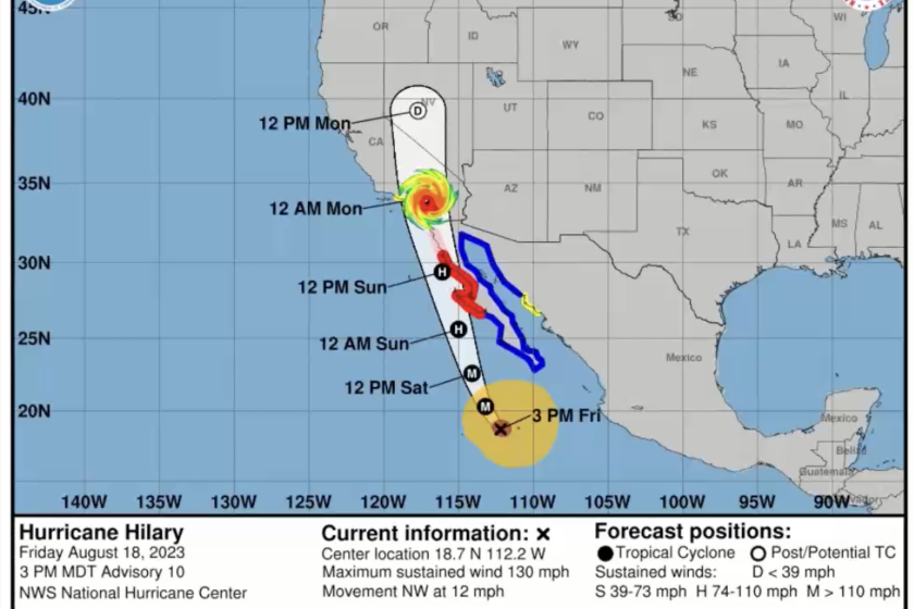
Interestingly, Hurricane Hilary is tracking slightly ahead of initial predictions. Forecasts indicate that San Diego County could experience tropical storm-force winds, characterized by sustained speeds exceeding 39 mph, as soon as Sunday morning.
The authorities are particularly vigilant about the developments on Sunday afternoon and evening across Southern California. While Hilary's trajectory has shifted slightly eastward, the risk of coastal flooding in Los Angeles County seems to have abated to some extent. However, the potential for flooding, especially in inland regions like deserts and mountains, remains a significant concern.
Here's a detailed breakdown of what's expected on Sunday:
Size and Velocity:
Hilary's sheer size is comparable to that of Arizona. As of Sunday morning, the hurricane has transitioned into a tropical storm, showcasing maximum sustained winds of 70 mph, retaining its capacity to trigger considerable flooding.
Areas of Focus:
The central risks posed by Hilary are rain-related issues and flooding, with a heightened focus on the deserts and mountains. Signs of roads transforming into rivers have already emerged in Baja California, indicating the potential for similar impacts in affected regions.
Forecasters express apprehension over the possibility of significant flood impacts, particularly in areas like San Bernardino and Inyo counties. Notably, the vulnerable Death Valley and Morongo Basin are projected to bear the brunt of major flooding. Specific routes, such as Death Valley and Highway 62 near Joshua Tree National Park, could also face closures.
Intense Rainfall:
The storm's rainfall carries the potential for exceptional rates, potentially exceeding one inch per hour and even surging up to 2 inches per hour according to some projections. This torrential rain can lead to catastrophic flooding, particularly in desert, mountain, or valley landscapes.
Recalling last year's "unprecedented rains," Death Valley encountered 1.7 inches of rainfall, a record-breaking downpour that triggered significant flooding and necessitated the shutdown of all park roads. In a span of 24 hours, select desert areas in Southern California could be exposed to a year's worth of rainfall, albeit not continuously, but in several intense rounds.
Coastal Influence:
The coastal regions are slated to experience less extreme but still substantial rainfall from Hilary. Locations such as Anaheim, Irvine, and San Clemente could witness up to 2.5 inches of rain, while San Diego might receive around 2 inches.
Inland and Basin Areas:
Across L.A. County, varied estimates indicate potential rainfall: Lancaster and Acton around 4 inches, Santa Clarita, Pasadena, and Northridge about 3 inches, and downtown Los Angeles, Long Beach, Redondo Beach, Pomona, and Westlake Village potentially receiving around 2 inches.
Catalina Concerns:
Catalina Island, particularly at Avalon and Two Harbors, is expected to encounter hazardous sea conditions within its harbors, leading to the evacuation of residents as a precaution.
Further Insights:
Winds, anticipated to be formidable enough to induce power outages and topple trees, are expected to reach their peak on Sunday afternoon, gradually subsiding into Monday. Peak gusts could soar as high as 81 mph at Joshua Tree National Park, accompanied by gusts reaching 67 mph in Wrightwood.
While the storm's eye is projected to cross into Mexican territory near Ensenada, followed by a northward trajectory just east of Tijuana and San Diego, the path may continue to evolve.
While coastal flooding risks exist, their magnitude could be minor if the storm adheres to its current path. However, a westward deviation might elevate the risk along L.A. County's coast.
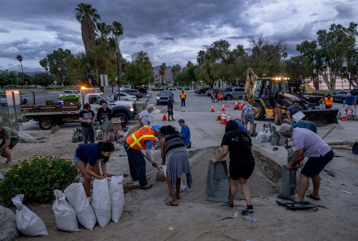
Given the anticipated adverse conditions, travel during Sunday afternoon and night is best postponed, with driving through flooded areas and sudden lane changes strongly discouraged. Preparedness with essentials like water, food, blankets, flashlights, and first aid supplies is advisable.
Historical context underscores the rare nature of such events. The last time a hurricane caused significant coastal damage in Long Beach was during Hurricane Marie in 2014, causing substantial losses. The storm's impacts have prompted authorities to take precautionary measures, including evacuations.
In the face of Hurricane Hilary's impacts, it's vital for affected communities to exercise caution and prioritize safety."
As a possible additional risk, thunderstorms and lightning carry a 20% to 30% likelihood, exacerbating the potential for flash floods. Airports are likely to face delays or cancellations, with Los Angeles International Airport expecting eastward winds that often lead to extensive delays.
Despite the potential for tornadoes, the probability remains low, as they tend to be fleeting occurrences within tropical systems. Waves are expected to peak on south-facing beaches, with Orange County and San Diego County anticipating heights ranging from 6 to 12 feet and 3 to 5 feet, respectively.

While coastal flooding risks exist, their magnitude could be minor if the storm adheres to its current path. However, a westward deviation might elevate the risk along L.A. County's coast.
Given the anticipated adverse conditions, travel during Sunday afternoon and night is best postponed, with driving through flooded areas and sudden lane changes strongly discouraged. Preparedness with essentials like water, food, blankets, flashlights, and first aid supplies is advisable.
Historical context underscores the rare nature of such events. The last time a hurricane caused significant coastal damage in Long Beach was during Hurricane Marie in 2014, causing substantial losses. The storm's impacts have prompted authorities to take precautionary measures, including evacuations.
In the face of Hurricane Hilary's impacts, it's vital for affected communities to exercise caution and prioritize safety.