
Hurricane Hilary Emerges as Significant Threat to Southern California with Rare Tropical Storm Warning

Hurricane Hilary, a formidable major hurricane, is charting an atypical course toward Southern California, a region not accustomed to such tropical disturbances. This unexpected phenomenon has the potential to unleash potent winds and extraordinary flooding.
Currently situated off the western shoreline of Mexico's Baja California, Hurricane Hilary has exhibited sustained maximum wind speeds of approximately 145 mph, firmly establishing itself as a Category 4 storm. However, as of Saturday morning, the hurricane's intensity has diminished to Category 3, registering maximum sustained winds of 125 mph.
Forecasts project that by the time Hilary reaches Southern California on Sunday, it will have further weakened into a tropical storm. Even before its arrival, the desert areas of Southern California could experience rainfall as early as Saturday.
Outlined below are six key insights concerning Hurricane Hilary:
- Unprecedented Warning: Notably, the National Hurricane Center has never before issued a tropical storm warning for Southern California, underscoring the exceptional nature of this event.
- Timing of Impact: The onset of tropical storm conditions in Southern California is anticipated by Sunday.
- Dual Threat in Baja California: Simultaneously, Baja California is poised to face hurricane conditions starting Saturday night, accompanied by substantial rainfall capable of triggering flash floods and landslides. This heightened risk will persist from late Friday through late Sunday.
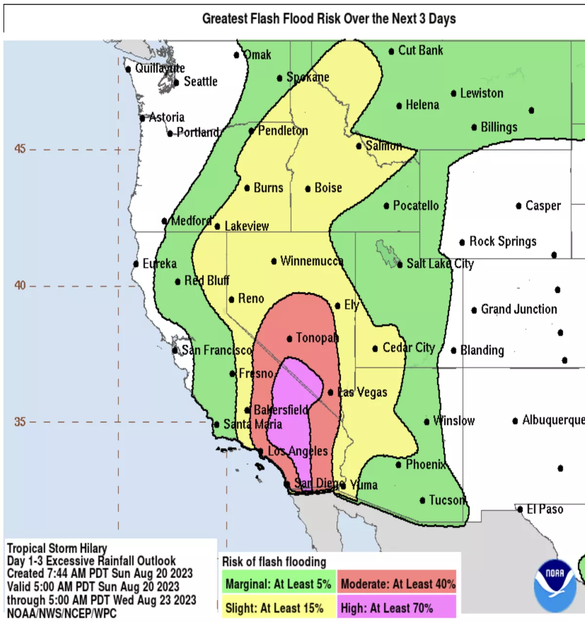
- Potential Flood Hazard: Southern California could grapple with a range of flooding scenarios, including flash floods, urban flooding, and arroyo flooding. Experts warn of the potential for unusual and perilous consequences.
- Imminent Rainfall: Precipitation estimates range from 3 to 6 inches across sections of Southern California and southern Nevada, with localized accumulations potentially reaching up to 10 inches. Forecasters caution that these conditions could lead to dangerous to catastrophic flooding, with particular concerns about desert regions experiencing sudden deluges.
- Vulnerable Areas: Among the locales at greatest risk for a confluence of wind, coastal flooding, and rain impacts, San Diego County, particularly the San Diego metropolitan region, stands out. The possibility of coastal flooding, exceeding a foot in height, is also worrisome for spots like Long Beach, notably Belmont Shores, and the low-lying stretches along the Orange County coast.
Additional Important Points:
- Strengthening Tropical Storm: Southern California may start witnessing the effects of tropical storm conditions starting Sunday.
- Baja California's Coastal Threat: The western coastline of Baja California is anticipated to encounter hurricane conditions from Saturday night onwards. Extensive hurricane watches or warnings stretch from Punta Abreojos north to Ensenada. Meanwhile, tropical storm watches and warnings remain in effect across other parts of Baja California and mainland Mexico, accompanied by the forecast of a "dangerous storm surge" liable to induce coastal flooding.